When Maps Explain Themselves: Legends, Style, and Finished Images in Ruby

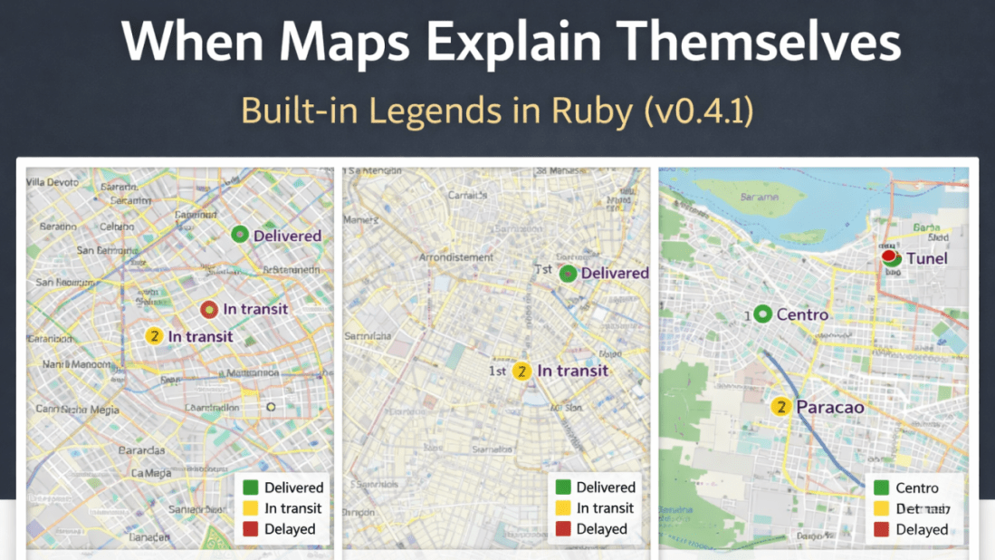
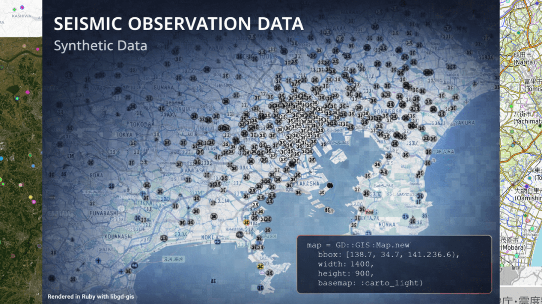
February 10, 2026 Introduction libgd-gis now supports legends, introducing a fundamental building block in map communication. With the release of v0.4.1, legends become a first-class feature of the rendering pipeline, pushing the library one step closer to covering the essential capabilities expected from a modern GIS engine. Legends are not just a visual accessory. They … Continue reading When Maps Explain Themselves: Legends, Style, and Finished Images in Ruby

A quick DEMO of Ruby-LibGD v0.2.4.

Scan to try 🎯 Live Demo Available Introducing MapView Render beautiful, production-ready maps directly from your Ruby backend. No external APIs. No dependencies. Just pure speed and control. ✓ Zero external dependencies ✓ Lightning-fast rendering ✓ Production-ready & battle-tested Try the Live Demo → Read Docs Not a tutorial, not a benchmark — just experimenting … Continue reading A quick DEMO of Ruby-LibGD v0.2.4.

Tackling Inevitable I/O Latency in Rails

February 6, 2026 Lessons from Kaigi on Rails 2025 on SSE and Async Modern Rails applications increasingly depend on external systems: third-party APIs, background services, data pipelines, and—more recently—AI and LLM inference. While Rails itself continues to evolve in performance and concurrency, I/O latency remains largely unavoidable in many real-world scenarios. At Kaigi on Rails … Continue reading Tackling Inevitable I/O Latency in Rails

Opening the Heart of libgd-gis

Opening the Heart of libgd-gis February 3, 2026 How Ruby Turns Coordinates into Maps (and Why Tests Matter) Maps look simple on the surface. You give them coordinates. They give you an image. But anyone who has gone even slightly deeper knows that coordinates are never just numbers. They are context. They are assumptions. They … Continue reading Opening the Heart of libgd-gis

Rendering Incremental Points on Maps with Ruby and Rails

Rendering Incremental Points on Maps with Ruby and Rails January 30, 2026 When working with maps in Ruby or Ruby on Rails applications, most solutions assume that all geospatial data must be prepared upfront — usually as GeoJSON layers. While this works well for static datasets, it becomes inefficient when dealing with event-driven data such … Continue reading Rendering Incremental Points on Maps with Ruby and Rails

Making Maps with Ruby

Making Maps with Ruby January 29, 2026 Static and animated cartography built directly from GeoJSON For a long time, generating maps from code meant working inside heavy ecosystems designed primarily for analysis. Those tools are powerful, but they are not always the right fit. In many practical scenarios, the problem is simpler and more concrete: … Continue reading Making Maps with Ruby

Understanding TypeProf: Design Goals, Limitations, and Effective Use in Ruby

Understanding TypeProf: Design Goals, Limitations, and Effective Use in Ruby January 28, 2026 TypeProf is an official type inference tool for Ruby that has gained attention as part of the ecosystem surrounding RBS, Steep, and Sorbet. Despite this visibility, it is frequently misunderstood and often perceived as “not working” by first-time users. This article analyzes … Continue reading Understanding TypeProf: Design Goals, Limitations, and Effective Use in Ruby

Ruby Rendering Seismic Observation Data

January 27, 2026 Scan to try 🎯 Live Demo Available Introducing MapView Render beautiful, production-ready maps directly from your Ruby backend. No external APIs. No dependencies. Just pure speed and control. ✓ Zero external dependencies ✓ Lightning-fast rendering ✓ Production-ready & battle-tested Try the Live Demo → Read Docs From Disaster Prevention to High-Performance Maps … Continue reading Ruby Rendering Seismic Observation Data

Stabilizing a Native Ruby GIS Engine with Docker, RuboCop, and CI

January 26, 2026 For many years, Ruby developers working with maps and geospatial data have relied on external tools or loosely coupled pipelines. ImageMagick, command-line utilities, and background processes became the norm, even though they were never designed to be deterministic GIS rendering engines. The result was fragile systems: slow, hard to debug, and difficult … Continue reading Stabilizing a Native Ruby GIS Engine with Docker, RuboCop, and CI

libgd-gis: A Practical GIS Rendering Engine for Ruby

January 23, 2026 Raster maps, GeoJSON overlays, and real-world cartography — without leaving Ruby. Over the last months, I’ve been working on libgd-gis, a GIS rendering engine built on top of libgd and designed specifically for Ruby developers who need static map generation without relying on browser-based toolchains or heavyweight GIS stacks. This article walks … Continue reading libgd-gis: A Practical GIS Rendering Engine for Ruby