libgd-gis: A Practical GIS Rendering Engine for Ruby

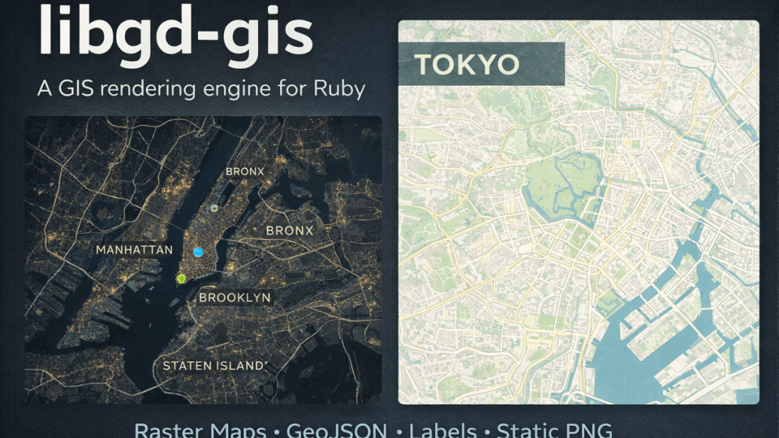
January 23, 2026 Raster maps, GeoJSON overlays, and real-world cartography β€” without leaving Ruby. Over the last months, I’ve been working on libgd-gis, a GIS rendering engine built on top of libgd and designed specifically for Ruby developers who need static map generation without relying on browser-based toolchains or heavyweight GIS stacks. This article walks … Continue reading libgd-gis: A Practical GIS Rendering Engine for Ruby

A New View of Earth, Powered by Ruby

January 22, 2026 libgd-gis, satellite imagery, and a new way to think about maps Most mapping libraries start from the same place: roads, labels, vectors, tiles. But what happens if the map itself is not the goal? What if the map is just a lens to observe the planet? This article is about how libgd-gis, … Continue reading A New View of Earth, Powered by Ruby

Imprint: Signed, Expiring Image Rendering with Dynamic Watermarks in Ruby

January 21, 2026 Distributing images securely is a recurring challenge in modern web applications. Whether for previews, confidential documents, or paid content, developers often need to ensure that images are not reused, hotlinked, or accessed indefinitely. Imprint is a Ruby gem that addresses this problem by providing signed, time-limited image rendering with dynamic watermarks, allowing … Continue reading Imprint: Signed, Expiring Image Rendering with Dynamic Watermarks in Ruby

map_view β€” Server-side maps for Ruby on Rails

For years, maps in Rails applications have lived almost entirely on the frontend:JavaScript libraries, external APIs, keys, variable costs, and a fair amount of friction. map_view starts from a simple question: What if maps in Rails were as simple as rendering a view? <%= map_for @locations %> That’s it. What is map_view? map_view is a … Continue reading map_view β€” Server-side maps for Ruby on Rails

libgd-gis v0.2.7.pre.alpha.1

January 16, 2026 Testing GIS animations in Ruby (exploratory work) Today, early in the morning, after releasing GIF and animation support in ruby-libgd, together with updated documentation, versioning, and examples, I decided to do something very concrete: spend the entire day stress-testing the alpha version of libgd-gis. And what better way to test animations than … Continue reading libgd-gis v0.2.7.pre.alpha.1

Ruby Now Has an Animated Map Engine (Alpha Preview)

Ruby Now Has an Animated Map Engine January 15, 2026 Building real-time, animated maps in pure Ruby β€” no JavaScript required. A new class of maps for Ruby Over the past weeks, we’ve been extending ruby-libgd and libgd-gis far beyond static image rendering. What started as a raster + GIS toolkit is now evolving into … Continue reading Ruby Now Has an Animated Map Engine (Alpha Preview)

ruby-libgd v0.2.2 β€” Text & Layout Foundations for Ruby Graphics

Text & Layout Foundations for Ruby Graphics January 14, 2026 The biggest limitation of most Ruby image libraries is not pixels β€” it’s text. Fonts, labels, positioning, alignment, rotation, and layout are what separate a toy renderer from a real graphics engine. Until now, ruby-libgd only exposed a very minimal wrapper around FreeType. It worked, … Continue reading ruby-libgd v0.2.2 β€” Text & Layout Foundations for Ruby Graphics

libgd-gis moves into serious cartography territory

January 13, 2026 Rivers of Europe and Entre RΓ­os rendered directly in Ruby Today marks a major milestone for libgd-gis: we crossed from β€œexperimental map renderer” into a real GIS-grade drawing engine. Using nothing but Ruby + libgd, we are now able to render continent-scale river networks, provincial hydrology, and complex GeoJSON layers with proper … Continue reading libgd-gis moves into serious cartography territory

Some fresh Ruby GIS gossip

January 8, 2026 I’ve been quietly working on two Ruby libraries that are starting to click together in a really interesting way: libgd-gis β€” the GIS brain: maps, basemaps, lines, polygons ruby-libgd β€” the raster engine: pixels, alpha, image scaling, compositing Over the last days I added: lines, polygons and basemap switching to libgd-gis (0.1.3) … Continue reading Some fresh Ruby GIS gossip

How Ruby Powers One of the Most Complex Healthcare Systems in the World

Inside DENTIS, the cloud dental platform built by Medley, Inc. In 2025, at RubyWorld Conference, Toshio Maki β€” Engineering Manager and Head of the Dental Clinic Business Unit at Medley, Inc. β€” presented one of the most impressive real-world applications of Ruby in modern healthcare p30-2. The talk, titled: β€œRuby powering Dental DX – Development … Continue reading How Ruby Powers One of the Most Complex Healthcare Systems in the World